Shoreline Erosion in the Central Harbour of Burrard Inlet
Tsleil-Waututh has stewarded the waters of Burrard Inlet since time out of mind, and in turn has benefitted from the sustainable conditions of the relatively sheltered waters.
In a stable system – as Burrard Inlet was for thousands of years – the processes of erosion, sediment transport, and deposition are relatively balanced within natural fluctuations. Under these conditions, shorelines remain relatively unchanged over centuries, allowing habitats, ecosystems, and human systems to develop.
In recent decades, however, erosion and deposition patterns have changed in Burrard Inlet. Community Elders and Knowledge Holders have observed an accelerated rate and extent of shoreline loss in the Central Harbour, including along Tsleil-Waututh Nation’s (TWN’s) main reserve, important cultural places, archaeological sites, and key habitats and beaches.
To better understand this growing concern of accelerated shoreline loss in Burrard Inlet, TWN has conducted research including developing a sediment transport model, installing wave monitoring buoys, and analyzing vessel traffic.
Findings from these studies, alongside community observations and Knowledge, provide increasing evidence that colonial activities have led to multiple causes driving shoreline loss in Burrard Inlet, including but not limiting to:
- Heavy vessel traffic creating powerful vessel wakes, capable of mobilizing sediment and contributing to shoreline erosion.
- Altered shorelines that have changed sediment transport pathways, causing more sediment to be deposited in deeper waters.
- Reduced sediment supply to the Central Harbour, largely due to the damming of the Seymour River.
- Loss of marine vegetation (e.g., kelp and eelgrass) has weakened or eliminated wave-dampening effects of near-shore habitats.
Eroding shorelines mean that each year, TWN sees their land base wash away bit by bit, including peoples’ front yards. Increased vessel wake, reduced sediment loads and shifting sediment transport pathways alter ecosystems and reduce available habitat for many species, such as shellfish.
We need to study and discuss the causes of these problems in order to find solutions. Therefore, this post summarizes two recent TWN-led studies in Burrard Inlet, the first focused on developing a sediment transport model, and the second on quantifying vessel traffic.
Sediment Transport Model
TWN worked with academic and industry partners to develop a computer model of circulation and sediment transport for Burrard Inlet, with a focus on sediment transport pathways in the Central Harbour. The model provides valuable insight and corroborates the observations and explanations of shoreline erosion provided by Tsleil-Waututh Elders and Knowledge Holders. Changes to sediment transport patterns – attributed to altered shorelines and decreases in sediment supply and marine vegetation – explain much of the shoreline loss occurring in the Central Harbour.
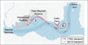
The model compared sediment transport pathways between Burrard Inlet’s pre-contact shoreline versus the present-day shoreline. The model indicated that when sediment was eroded from the pre-contact shoreline, particles tended to stay close to shore where they could resettle and feed the shoreline to balance and counteract ongoing erosion. When analyzing present-day conditions, the model shows that when sediment is mobilized from shore, it tends to be washed away and sink into deep eddies in the Central Harbour or transported up Indian Arm.
Figure 1. Pathways of sediment transport that erodes from the shorelines along the TWN reserve and Cates Park with the 1792 and 2019 shorelines.
This change in sediment transport is likely due to changes to the shape of the inlet. Shoreline armouring and industrial infilling of mudflats and inter-tidal areas has resulted in a highly modified shoreline and constriction of the Second Narrows. The Seymour River estuary has been radically altered and the river path channelized. These landscape alterations have changed the directions and velocity of currents, and subsequently sediment transport pathways through the inlet.
The model was particularly consistent with Tsleil-Waututh observations of shoreline erosion between Whey-ah-Wichen/Cates Park and the TWN reserve, as well as with the location and direction of offshore eddies. However, the model did not fully capture the dynamics of Maplewood Mudflat. Tsleil-Waututh understands the Mudflats to be infilling and expanding into the Central Harbour – which further contributes to the anthropogenic constriction of Second Narrows, and to the velocity of water currents entering the Central Harbour.
Additionally, the model showed that all sediment reaching shorelines in the Central Harbour enters through the Second Narrows and highlighted the Seymour River as an important sediment supply. The Seymour River was dammed in the 1960s, however, which generally reduces sediment load in rivers. The model suggests the damming of the Seymour River may have significantly reduced the sediment supply to shorelines in the Central Harbour.
Near-shore marine vegetation are understood to dampen wave action, retain sediment, and protect shorelines from erosion. Tsleil-Waututh Elders speak of once abundant kelp and eelgrass beds in the Central Harbour. These near-shore ecosystems would reduce water current velocities and provide nursery habitat for many marine species.
Compared to pre-contact times, there has been a dramatic loss of marine vegetation in Burrard Inlet. The sediment transport model indicates that the loss of marine vegetation in the Central Harbour has left shorelines more exposed to erosional energy (e.g., from waves, wakes, storm surges, etc.) and that coastal marine sediments are more readily destabilized and mobilized.
Vessel Traffic
TWN commissioned a study, conducted by Coastal Resource Mapping Ltd., to quantify marine vessel traffic in Burrard Inlet and characterize heavy commercial and industrial marine traffic in local waters. To our knowledge, this is the first publicly available information that quantifies metrics such as total vessel counts, operating hours, and vessel types in Burrard Inlet. This information is imperative to begin to evaluate marine vessel traffic trends in Burrard Inlet and to determine related impacts to TWN’s rights and ways of life.
Alongside previous research demonstrating that vessel-generated wakes increase wave energy in eastern Burrard Inlet by up to 4.6 times, this new research corroborates Tsleil-Waututh observations that the constant presence, composition and activities of vessels in the Central Harbour generate frequent and powerful wakes capable of eroding the shoreline.
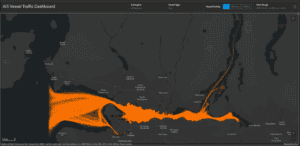
Our vessel traffic study showed a total of 2,700 vessels with automatic identification system (AIS) equipment, which tracks marine vessels, visited Burrard Inlet in 2021, spending 3.2 million hours in its waters. That means that on average across the year, for every hour of every day, there are almost 700 AIS tracked vessel-operating hours in the inlet.
Figure 2. AIS tracking data from tugboats operating in Burrard Inlet in 2021.
Marine vessel traffic was greatest in the Outer, Inner and Central Harbours. However, Transport Canada does not require AIS equipment on all vessels and many vessels are exempt, including most pleasure crafts and recreational vessels, which could constitute upwards of 60% of total vessel traffic in eastern Burrard Inlet. Therefore, vessel traffic estimates are low due to the missing data from vessels without tracking equipment. The true number of total vessels and operating hours in Burrard Inlet is undoubtedly much higher.
Pleasure craft and tugboats represented most of the vessel traffic in the Central Harbour during 2021. From the previous wave monitoring study, we know these vessel types are also responsible for the strongest and most frequent wave activity. Tankers are an added source of powerful wakes, though tankers transit the Central Harbour less frequently and in lower numbers than pleasure craft and tugs.
There is at least a 40% increase in traffic in the Central Harbour in the summer months, largely attributed to pleasure craft. This corresponds with a seasonal signal of larger and more frequent wakes. In fact, based on wave activity – there could be as much as three times more vessel traffic in summer months versus winter months, largely attributed to pleasure craft.
We do not currently have a comparison of marine vessel traffic over multiple years. According to the Vancouver Fraser Port Authority, trade through the Port of Vancouver has been increasing steadily for a decade and is forecasted to keep growing at about 3.5% annually. Additionally, Metro Vancouver is expected to grow its population by one million people by 2050[1]. Increased marine traffic is a mounting concern to TWN. TWN sees a need for better monitoring and collaborative planning to proactively address the increase of marine vessel traffic associated with this projected growth.
The results of the marine vessel traffic study emphasized to TWN the need to more accurately quantify vessels without AIS tracking equipment, including most pleasure crafts in Burrard Inlet. We see a further need for the assessment and monitoring of near-shore and shoreline impacts associated with pleasure craft infrastructure including marinas, docks, and anchorages.
Closing
Many factors and aspects of colonial development contribute to shoreline loss in Burrard Inlet. Changes to the shape of the inlet, such as infilling intertidal areas and the constriction of the Second Narrows, have changed how water currents interact with the shoreline in the Central Harbour, and sediment that is mobilized is now deposited in deep waters as opposed to along shorelines and beaches. This change in sediment transport, in combination with decreased sediment supply and loss of marine vegetation – may contribute to shoreline retreat in the Central Harbour.
Heavy marine vessel traffic, and the associated vessel wakes, are also likely a contributing factor further eroding the natural shorelines that remain in the inlet. Marine vessel traffic in Burrard Inlet has seasonal signals, as does the local ecosystem and TWN way of life. The overall cumulative effects of marine vessel traffic in Burrard Inlet needs to be considered alongside life histories of culturally and ecologically significant species, TWN harvesting times, and TWN cultural activities and ceremonial practices.
These findings must be considered alongside other factors, such as climate change. TWN’s earlier Climate Change Resiliency Planning found that sea level rise, more severe storm surges and winds, and overland flooding will increasingly contribute to and exacerbate shoreline erosion, increasing the urgency to implement management decisions that address shoreline loss, such as the recommendations included in the summary report of the vessel traffic study.
Future work will enable us to articulate the cumulative effects of shoreline erosion on Tsleil-Waututh rights, title, traditional economy, and way of life. TWN management objectives, decision-making, and recognized governance are required to sufficiently assess and address these complex issues in Burrard Inlet.
[1]Vancouver Fraser Port Authority, “Port of Vancouver,” Vancouver Fraser Port Authority, 2022. [Online]. Available: https://www.portvancouver.com/about-us/. [Accessed 06/03/2023].


